 Jerusalem Old City Tour
Jerusalem Old City Map
This Jerusalem Old City map guide shows every gate, holy site and museum you will find inside the 0.9 square kilometre walled city, grouped by quarter. The walls run about 4.5 km and carry seven working gates. Use the quarter-by-quarter tables to plan a route, then decide whether to walk it alone or join one of the Jerusalem Old City tours that cover the same ground with a guide.
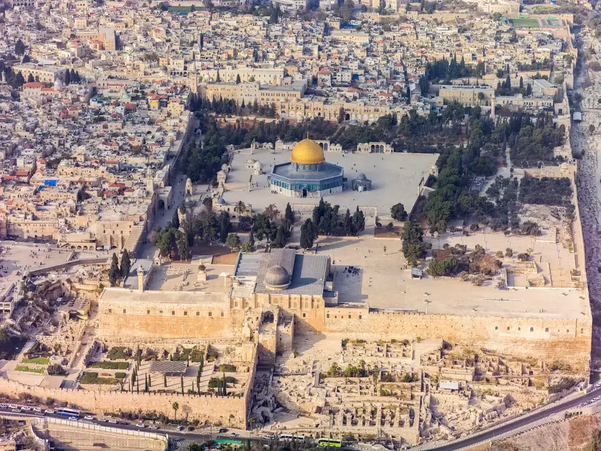
An aerial view of the Temple Mount and the southeastern part of the Old City. Photo: Godot13, CC BY-SA 4.0, via Wikimedia Commons
Quick answer The Old City on one map
The Old City of Jerusalem is a walled area of 0.9 square kilometres (0.35 sq mi) divided into four quarters: Muslim, Christian, Jewish and Armenian. Seven gates are in use and one, the Golden Gate, is sealed. The walls run about 4.5 km and stand 5 to 15 m high.
Key takeaways
- See how the quarters and gates fit together in the section on how the Old City is laid out.
- Every place on the map, with links to deeper guides, sits in the quarter-by-quarter tables.
- The nearest tram stops and how the light rail works are in transport stops around the walls.
- Want the same route with a guide? Compare the 4-hour Old City walking tour and the 3-hour half-day Old City tour.
The Old City of Jerusalem on One Map
Every gate, holy site, museum and viewpoint covered on this site, with the light rail stops by the walls. Bubbles grow with the number of tours on this site that stop there, and the list under the map holds the same places.
-
Jaffa Gate
3 of the toursMain western entrance with the vehicle breach, the Tower of David and the tourist information centre beside it. More on Jaffa Gate.
Stops here: Jerusalem: Guided Walking Tour of the Old City, Jerusalem: Old City Shabbat Experience and Walking Tour, Jerusalem Old City Half-Day Tour
-
New Gate
No tourNewest gate (1887 to 1889), the quickest way in from West Jerusalem to the Christian Quarter.
No guided tour stops here. Self-drive only.
-
Damascus Gate
No tourBusiest northern gate, steps lead down into the Muslim Quarter bazaar, Roman gate remains below. More on Damascus Gate.
No guided tour stops here. Self-drive only.
-
Herod's Gate
No tourQuiet northern gate into the Muslim Quarter with a short walk to the Via Dolorosa.
No guided tour stops here. Self-drive only.
-
Lions' Gate
No tourEastern gate where the Via Dolorosa walk begins, near St Anne's.
No guided tour stops here. Self-drive only.
-
Golden Gate
No tourSealed double gate in the eastern wall of the Temple Mount, visible from the Mount of Olives side.
No guided tour stops here. Self-drive only.
-
Dung Gate
No tourClosest gate to the Western Wall plaza, the only wheelchair route to it and the main vehicle exit.
No guided tour stops here. Self-drive only.
-
Zion Gate
No tourSouthern gate between the Armenian and Jewish quarters and the way to Mount Zion.
No guided tour stops here. Self-drive only.
-
Western Wall
8 of the toursOpen 24 hours, the prayer plaza with the exposed Herodian wall. More on Western Wall.
Stops here: Jerusalem: Guided Walking Tour of the Old City, From Tel Aviv: Jerusalem Old City Guided Tour, Jerusalem Boutique Tour from Tel Aviv, From Tel Aviv: Jerusalem and Bethlehem Guided Day Trip, Jerusalem Half Day Tour: Holy Sepulchre and Western Wall, Jerusalem: Old City Shabbat Experience and Walking Tour, Jerusalem Old City Half-Day Tour, Jerusalem: Private Holy City Tour with Hotel Pickup
-
Western Wall Tunnels entrance
No tourTunnel routes start from the lobby left of the prayer plaza and need advance booking. Point is the tunnel's own coordinate. More on Western Wall Tunnels entrance.
No guided tour stops here. Self-drive only.
-
Temple Mount / Haram al-Sharif
3 of the toursPlatform of about 37 acres, non-Muslim visitors enter by the Mughrabi bridge in set morning hours. More on Temple Mount / Haram al-Sharif.
Stops here: Jerusalem: Guided Walking Tour of the Old City, From Tel Aviv: Jerusalem Old City Guided Tour, Jerusalem Boutique Tour from Tel Aviv
-
Dome of the Rock
No tourCompleted 691 to 692 CE, the gilded dome sits on the Temple Mount. More on Dome of the Rock.
No guided tour stops here. Self-drive only.
-
Al-Aqsa Mosque
No tourThe main prayer hall at the southern end of the Temple Mount. More on Al-Aqsa Mosque.
No guided tour stops here. Self-drive only.
-
Church of the Holy Sepulchre
7 of the toursCalvary, Stone of Unction and the Aedicule under one roof, free to enter. More on Church of the Holy Sepulchre.
Stops here: Jerusalem: Guided Walking Tour of the Old City, From Tel Aviv: Jerusalem Old City Guided Tour, Jerusalem Boutique Tour from Tel Aviv, From Tel Aviv: Jerusalem and Bethlehem Guided Day Trip, Jerusalem Half Day Tour: Holy Sepulchre and Western Wall, Jerusalem Old City Half-Day Tour, Jerusalem: Private Holy City Tour with Hotel Pickup
-
Ecce Homo Arch and Basilica (Via Dolorosa)
6 of the toursSecond station area on the Via Dolorosa, near the Flagellation church. Coordinates are the OSM arch node. More on Ecce Homo Arch and Basilica.
Stops here: Jerusalem: Guided Walking Tour of the Old City, From Tel Aviv: Jerusalem Old City Guided Tour, From Tel Aviv: Jerusalem and Bethlehem Guided Day Trip, Jerusalem Walking Tour: In the Footsteps of Jesus, Jerusalem Old City Half-Day Tour, Jerusalem: Private Holy City Tour with Hotel Pickup
-
Church of St Anne and Pool of Bethesda
1 of the toursCrusader church and excavated pools just inside Lions' Gate. Coordinates are the pool's Wikidata point.
Stops here: Jerusalem Walking Tour: In the Footsteps of Jesus
-
Tower of David Museum
1 of the toursCitadel museum by Jaffa Gate with the Phasael Tower viewpoint and night shows. More on Tower of David Museum.
Stops here: Jerusalem: Old City Shabbat Experience and Walking Tour
-
Hurva Synagogue
2 of the toursRebuilt in 2010, the dome is a Jewish Quarter landmark. More on Hurva Synagogue.
Stops here: From Tel Aviv: Jerusalem Old City Guided Tour, Jerusalem: Old City Shabbat Experience and Walking Tour
-
Cardo
3 of the toursExcavated Roman and Byzantine main street, now a covered shopping arcade. More on Cardo.
Stops here: From Tel Aviv: Jerusalem Old City Guided Tour, From Tel Aviv: Jerusalem and Bethlehem Guided Day Trip, Jerusalem: Private Holy City Tour with Hotel Pickup
-
Davidson Center and Archaeological Park
No tourSouthern Steps and the Second Temple street, by the Dung Gate approach. More on Davidson Center and Archaeological Park.
No guided tour stops here. Self-drive only.
-
Cathedral of St James
No tourArmenian cathedral open for short morning and afternoon services only. More on Cathedral of St James.
No guided tour stops here. Self-drive only.
-
Church of the Redeemer
No tourLutheran church in the Muristan with a bell tower viewpoint.
No guided tour stops here. Self-drive only.
-
City of David
1 of the toursArchaeological park with the Gihon Spring and the Siloam Tunnel, south of the Dung Gate. More on City of David.
Stops here: Jerusalem: City of David and Underground Jerusalem Day Tour
-
Cenacle (Upper Room)
2 of the toursMount Zion building traditionally linked to the Last Supper.
Stops here: Jerusalem: Guided Walking Tour of the Old City, Jerusalem: City of David and Underground Jerusalem Day Tour
-
Dormition Abbey
No tourBenedictine abbey on Mount Zion, church dedicated in 1910.
No guided tour stops here. Self-drive only.
-
Mount of Olives viewpoint (Seven Arches Hotel)
3 of the toursClassic panorama of the Old City from the summit road. More on Mount of Olives viewpoint.
Stops here: From Tel Aviv: Jerusalem Old City Guided Tour, Jerusalem Boutique Tour from Tel Aviv, Jerusalem: City of David and Underground Jerusalem Day Tour
-
Church of All Nations (Gethsemane)
1 of the toursBasilica of the Agony beside the Gethsemane garden at the foot of the Mount of Olives. More on Church of All Nations.
Stops here: Jerusalem Walking Tour: In the Footsteps of Jesus
-
Jaffa Gate tourist information centre
No tourFree maps at Omar Ben el-Hatab Square inside Jaffa Gate. Coordinates are the gate's, so the point is approximate.
No guided tour stops here. Self-drive only.
-
Light rail City Hall stop
No tourNearest tram stop to Jaffa Gate, 5 to 7 minutes on foot per the Foundation. Coordinates are Safra Square (City Hall) as the stop's neighbour, so approximate.
No guided tour stops here. Self-drive only.
-
Light rail Damascus Gate stop
No tourTram stop for the northern entrance to the Old City.
No guided tour stops here. Self-drive only.
How the Old City Is Laid Out
The Old City is small enough to cross on foot, but its four quarters and eight gates are not arranged evenly, so a map helps before you set out.
One Square Kilometre, Four Quarters
The walls enclose 0.9 square kilometres (0.35 sq mi). The Muslim Quarter sits in the northeast, the Christian Quarter in the northwest, the Jewish Quarter in the southeast and the Armenian Quarter, the smallest, in the southwest. Population counts from 2020 give about 21,850 residents in the Muslim Quarter, 3,870 in the Christian Quarter, 3,240 in the Jewish Quarter and 2,160 in the Armenian Quarter. The Muslim Quarter is also the largest by area, covering 31 hectares (77 acres), while the Armenian Quarter covers 0.126 km2, about 14 percent of the city.
The Old City was added to the UNESCO World Heritage list in 1981 and listed as endangered in 1982. If you want more background on the division itself, see the guide to the four quarters of Jerusalem.
The Walls and Their Dates
The present walls were built under Ottoman Sultan Suleiman the Magnificent. The Old City article gives 1535 to 1542, while the Gates article says 1533 to 1540. They run about 4.5 km, stand 5 to 15 m high, are about 3 m thick at the base and carry 35 towers. Suleiman's walls originally had six gates, and the New Gate was added later, leaving seven gates in use today.
Two more sets of gates exist on the map but cannot be walked through. The Golden Gate in the eastern wall of the Temple Mount is sealed, and the Single, Double and Triple Gates, also called the Huldah Gates, in the southern wall are sealed as well. The full list is in the guide to the gates of Jerusalem Old City.
The Eight Gates at a Glance
The Gates article names eight gates: Jaffa, New, Damascus, Herod's, Lions', Golden, Dung and Zion. Knowing which quarter each opens into is the fastest way to read any Old City map. The table below lists them in clockwise order starting from the west, with the Arabic and Hebrew names where the record gives them.
| Gate | Wall side | Opens into | Note |
|---|---|---|---|
| Jaffa Gate | West | Christian Quarter, with the Muslim Quarter ahead and the Armenian Quarter on the right | Bab al-Khalil in Arabic, Sha'ar Yafo in Hebrew, gate tower from 1538, vehicle breach cut in 1898 |
| New Gate | North | Christian Quarter | Built 1887 to 1889 under Sultan Abdul Hamid II, about 790 m above sea level, the highest point of the walls |
| Damascus Gate | North | Muslim Quarter bazaar | Bab al-Amoud in Arabic, built in present form in 1537 over a Roman gate from around 129 to 130 CE |
| Herod's Gate | North | Muslim Quarter | Bab al-Sahira in Arabic, Sha'ar HaPerachim (Flowers' Gate) in Hebrew, current form from 1875 |
| Lions' Gate | Northeast | Muslim Quarter, start of the Via Dolorosa | Built 1538 and 1539, about 13.7 m tall, also called St Stephen's Gate |
| Golden Gate | East | Sealed, on the Temple Mount wall | Sha'ar HaRahamim, visible from the Mount of Olives side |
| Dung Gate | South | Jewish Quarter and the Western Wall plaza | Built in the 16th century as a 1.5 m pedestrian opening, widened for vehicles in 1952 and again in 1984 and 1985 to 4.5 m |
| Zion Gate | South | Between the Armenian and Jewish quarters | Bab an-Nabi Dawud in Arabic, built in July 1540, restored in 2008 |
The Places on the Map, Quarter by Quarter
Every gate, holy site, museum and viewpoint around the Old City, sorted by quarter. Names link to fuller guides where one exists.
Muslim Quarter
The largest quarter runs from Lions' Gate in the east, along the north wall of the Temple Mount, to Damascus Gate. The first seven Stations of the Cross lie here, and the Via Dolorosa is traditionally entered from Lions' Gate. The Cotton Merchants' Market in this quarter was rebuilt in 1336 by the Mamluk emir Tankiz.
The Temple Mount is mapped in this quarter.
| Place | Kind | What it is |
|---|---|---|
| Damascus Gate | Gate | Busiest northern gate, steps lead down into the Muslim Quarter bazaar, Roman gate remains below |
| Herod's Gate | Gate | Quiet northern gate into the Muslim Quarter with a short walk to the Via Dolorosa |
| Lions' Gate | Gate | Eastern gate where the Via Dolorosa walk begins, near St Anne's |
| Golden Gate | Gate | Sealed double gate in the eastern wall of the Temple Mount, visible from the Mount of Olives side |
| Temple Mount / Haram al-Sharif | Holy site | Platform of about 37 acres, non-Muslim visitors enter by the Mughrabi bridge in set morning hours |
| Dome of the Rock | Holy site | Completed 691 to 692 CE, the gilded dome sits on the Temple Mount |
| Al-Aqsa Mosque | Holy site | The main prayer hall at the southern end of the Temple Mount |
| Ecce Homo Arch and Basilica (Via Dolorosa) | Holy site | Second station area on the Via Dolorosa, near the Flagellation church |
| Church of St Anne and Pool of Bethesda | Holy site | Crusader church and excavated pools just inside Lions' Gate |
Christian Quarter
The northwest quarter holds about 40 holy sites and the Church of the Holy Sepulchre. David Street and Christian Quarter Road are its main shopping routes. Two of its gates, Jaffa and New, open toward West Jerusalem.
Jaffa Gate is the meeting point for several guided walks, including the dual narrative tour with two guides, one Jewish Israeli and one Palestinian, which starts on the plaza just outside.
| Place | Kind | What it is |
|---|---|---|
| Jaffa Gate | Gate | Main western entrance with the vehicle breach, the Tower of David and the tourist information centre beside it |
| New Gate | Gate | Newest gate (1887 to 1889), the quickest way in from West Jerusalem to the Christian Quarter |
| Church of the Holy Sepulchre | Holy site | Calvary, Stone of Unction and the Aedicule under one roof, free to enter |
| Church of the Redeemer | Holy site | Lutheran church in the Muristan with a bell tower viewpoint |
| Jaffa Gate tourist information centre | Transport | Free maps at Omar Ben el-Hatab Square inside Jaffa Gate |
Jewish Quarter
The southeast quarter covers roughly 28 to 29 acres. The quarter surrendered on 28 May 1948, and Chief Rabbi Herzog said 22 of the Old City's 27 synagogues had been razed. The Hurva Synagogue standing today was rebuilt in 2010, its dome now the quarter's landmark.
The Western Wall is in this quarter, and Dung Gate is the closest gate to the Western Wall plaza.
| Place | Kind | What it is |
|---|---|---|
| Dung Gate | Gate | Closest gate to the Western Wall plaza, the only wheelchair route to it and the main vehicle exit |
| Western Wall | Holy site | The prayer plaza with the exposed Herodian wall |
| Western Wall Tunnels entrance | Museum | Tunnel routes start from the lobby left of the prayer plaza and need advance booking, see the Western Wall Tunnels tour |
| Hurva Synagogue | Holy site | Rebuilt in 2010, the dome is a Jewish Quarter landmark |
| Cardo | Quarter sight | Excavated Roman and Byzantine main street, now a covered shopping arcade |
| Davidson Center and Archaeological Park | Museum | Southern Steps and the Second Temple street, by the Dung Gate approach |
Armenian Quarter
The smallest quarter, 0.126 km2 in the southwest, has held an Armenian community since the 4th century, described as the oldest living diaspora community outside Armenia. The Armenian Gulbenkian Library was founded in 1925, opened in 1932 and holds about 100,000 volumes. Zion Gate on its southern side leads out toward Mount Zion.
| Place | Kind | What it is |
|---|---|---|
| Zion Gate | Gate | Southern gate between the Armenian and Jewish quarters and the way to Mount Zion |
| Tower of David Museum | Museum | Citadel museum by Jaffa Gate with the Phasael Tower viewpoint and night shows |
| Cathedral of St James | Holy site | Armenian cathedral with short daily opening windows in the morning and afternoon |
Outside the Walls
Several of the best views and sites sit just beyond the 4.5 km of walls. The Mount of Olives across the Kidron Valley carries the classic panorama, while Mount Zion to the south holds the Cenacle and Dormition Abbey, both just outside the walls. The City of David archaeological park lies south of Dung Gate, and a guided option for that area is the City of David and Underground Jerusalem day tour.
| Place | Kind | What it is |
|---|---|---|
| City of David | Museum | Archaeological park with the Gihon Spring and the Siloam Tunnel, south of the Dung Gate |
| Cenacle (Upper Room) | Holy site | Mount Zion building traditionally linked to the Last Supper |
| Dormition Abbey | Holy site | Benedictine abbey on Mount Zion, church dedicated in 1910 |
| Mount of Olives viewpoint (Seven Arches Hotel) | Viewpoint | Classic panorama of the Old City from the summit road |
| Church of All Nations (Gethsemane) | Holy site | Basilica of the Agony beside the Gethsemane garden at the foot of the Mount of Olives |
| Light rail City Hall stop | Transport | Nearest tram stop to Jaffa Gate, 5 to 7 minutes on foot per the Foundation |
| Light rail Damascus Gate stop | Transport | Tram stop for the northern entrance to the Old City |
Transport Stops Around the Walls
The light rail stops near the walls are one way to reach the Old City.
The Red Line and Its Old City Stops
The Jerusalem Light Rail Red Line serves Jaffa Center, City Hall and Damascus Gate near the Old City. City Hall is the nearest stop to Jaffa Gate, 5 to 7 minutes on foot according to the Western Wall Heritage Foundation, and Damascus Gate serves the northern entrance. The Red Line is 22.5 km long with 35 stations and opened in December 2011.
Payment uses the Rav-Kav card. Trains run every 3 minutes at rush hour and every 6 minutes otherwise. There is no daytime Shabbat service and trains resume after Shabbat ends, so check the operator for current fares and hours.
Arriving From Further Out
The train from Jerusalem Yitzhak Navon station to Tel Aviv takes about 30 minutes, and the Jerusalem to Ben-Gurion Airport train about 25 minutes. Yitzhak Navon station opened on 25 September 2018 about 80 m below street level, sits beside the Central Bus Station and connects directly to the Red Line. Bus 480 to Tel Aviv's Arlozorov station takes about 50 minutes and runs roughly every 20 minutes, while bus 405 goes to Tel Aviv Central Bus Station about every 30 minutes. Buses do not run on Shabbat, from Friday afternoon to Saturday evening. More detail is in the guide to getting from Tel Aviv to Jerusalem.
Drivers should note that the vehicle breach beside Jaffa Gate is the main route for cars into the Old City, and the Jaffa Gate vehicle checkpoint runs Sunday to Thursday 9:00 to 18:00 and Friday and holiday eves 9:00 to 13:00. Paid parking near Jaffa Gate is at the Mamilla Boulevard or Karta car parks.
Sources: Jerusalem Light Rail and itraveljerusalem
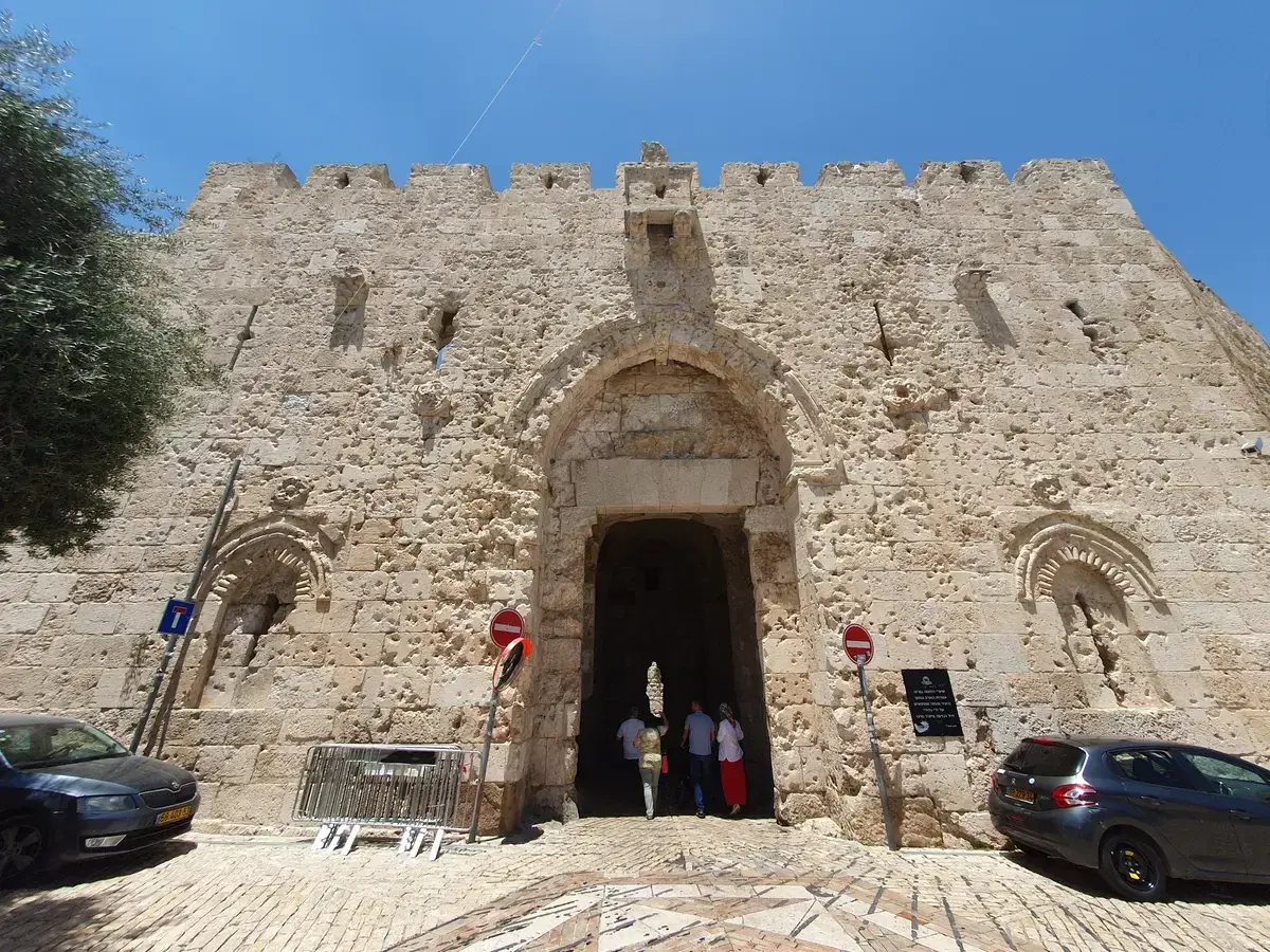
The pitted stone face of Zion Gate in the southern wall. Photo: Bukvoed, CC BY 4.0, via Wikimedia Commons
Old City Map Questions
How long does it take to walk around the Old City of Jerusalem?
The walls run about 4.5 km, so a full circuit of the walls is a walk of that length, though no walking time for it is published here. A guided circuit of the quarters themselves takes about 4 hours on the Old City walking tour, which starts and ends at Jaffa Gate.
Where is the Old City of Jerusalem located?
It is the walled 0.9 square kilometre heart of Jerusalem, bounded by walls about 4.5 km long with seven working gates. The map section above shows the four quarters inside it, and New Gate is the quickest way in from West Jerusalem.
Is the Old City of Jerusalem the same as Jerusalem?
No. The Old City is the 0.9 square kilometre walled core of a much larger city. Modern Jerusalem spreads far beyond the walls, connected to the Old City by the light rail Red Line with stops at City Hall, Damascus Gate and Jaffa Center.
How many gates does the Old City have?
Eight named gates appear on the map: Jaffa, New, Damascus, Herod's, Lions', Dung, Zion and the sealed Golden Gate. Seven are in use. The full list, with dates and names in Arabic and Hebrew, is in the guide to the gates of Jerusalem Old City.
Which gate should I use for the Western Wall?
Dung Gate. It is the closest gate to the Western Wall plaza, the only wheelchair route to it and the main vehicle exit from the Old City. Dung Gate was built in the 16th century as a 1.5 m pedestrian opening and widened for vehicles in 1952 and again in 1984 and 1985.
Where can I get a free paper map of the Old City?
The tourist information centre at Omar Ben el-Hatab Square inside Jaffa Gate hands out free maps. Jaffa Gate is also where the 4-hour Old City walking tour starts and ends, so it is a practical first stop for orientation.